
Currently I’m involved in an AutoCAD BGT pilot project. The motivation for this pilot is the introduction of the Registration Large Scale Topography ( BGT ) conform the classification-model of Informationmodel Large Scale Geography ( IMGeo ).
 To migrate from linework in drawings into polygon-objects in a database, the lines that’ll become the boundaries of the polygons have to meet certain criterias.
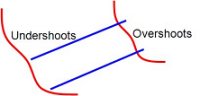
The lines have to connect to each other. Is one of the lines to short, than there might be an undershoot. Are the lines crossing each other and is there no node on the crossing, than there might be an overshoot.
In both cases the lines have to be cut and a node has to be made. Otherwise we cannot create polygons.
AutoCAD Map has CleanUp functionality to perform those cleaning operations (semi)automatically and Topology functionality to create the polygons.
in the next posts I will dive into more details of this workflow
One Reply to “From AutoCAD Map DWG to BGT conform IMGeo”