AutoCAD blocks as MapGuide 6.5 symbols

Last week I got the following question: “how can I use AutoCAD blocks as MapGuide 6.5 symbols ?

In the current system configuration, AutoCAD drawings are exported into several SDF-files and Access-tables. The texts and point-objects are exploded first to be exported into lines. It was never necessary to define point-symbols for MapGuide.

Currently the drawings are migrated into Oracle Spatial ( as part of a BGT-project ). The texts and point-objects are stored as Points in the database. The matching texts become attributes and can be displayed as labels. However for the point-symbols they would like to have the same symbols as in CAD, to give the map the same look and feel in the web-viewer.

MapGuide 6.5 has a Symbol Manager utility, to build a library of symbols.
AutoCAD has an Export command, to export AutoCAD blocks into WMF-files.

This solved the question.

AcClassify Workflow utility ( update )

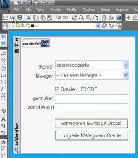
AcClassify Workflow utilityAt one of the migration projects where I am involved, the source data is managed in AutoCAD Map and there must be a regular update of the data posted into an Oracle Spatial database. From this Oracle database the large scale data is shared with the GIS-department and used for web-applications. To support this migration process I have developed an AcClassify Workflow utility.

The customer – a Dutch province – has stored their large scale basemaps in DWG-files into a very detailed folder structure on a fileserver. For each provincial road there is a sub-folder, with topografie but also other sub-folders with DWG’s for the theme’s like roadsigns and green management etc.

The Workflow utility – a C# application, that runs inside AutoCAD Map – gives in the UI the possibility to select the roadnumber, the option to delete old data from that roadnumber from Oracle and to upload the new data into Oracle using AcClassify.

If this is an update, than de utility will remove the old data from that roadnumber from their respective feature tables ( for roads, water, buildings etc. ) using SQL Delete statements. Next the utility creates the necessary AcClassify config XML-files ( adding roadnumber, Oracle schema-name etc. ). Than the AcClassify process is started using API-functionality.

With this the workprocess, with a lot of manual action, is reduced to a userfriendly AcClassify Workflow utility.

New : there is an update of this utility that starts the AcClassify process using API-functionality

AutoCAD Map/FDO – Scale Ranges

seen on Neal’s blog – CAD and GIS Integration

In the previous post I’ve described how to use a Spatial Query to limit the amount of GIS-data on your work-session.
But here is an other option: Scale Ranges.

An AutoCAD Map or Civil user can have as many Scale Ranges as necessary. This gives the possibility to setup which details are visible at what scale level.
When the map is opened, for example only road-centerlines are visible, zooming into a certain scale the houses-layer turns on and the centerlines-layer is replaced by a layer with the roadsides etc.

A combination of Spatial Query and Scale Ranges makes is possible to work with large amounts of GIS-data in a CAD-environment.

Scale Ranges
The Scale Range functionality is available in the Style Editor user interface.

AutoCAD Map/FDO – Spatial Query

seen on Neal’s blog – CAD and GIS Integration

GIS-data is in general on a complete other scale available than CAD-users need for their projects. Importing that GIS-dataset into a CAD-environment gives an overkill.
When talking with AutoCAD Map or Civil users about connecting to GIS-data using FDO-technology, they reject because it is still to much data.

For example an AutoCAD Civil 3D user has to develop a terrain-model and calculate volumes for a new housing construction area.
It would be very usefull to add the soil-layer from GIS, but not the whole province or municipality, only limited to the area needed for the project.

This is possible by adding a Spatial Query – by rectangle or polygon – when connecting to the data.

Spatial Query
The Spatial Query functionality is available in the Data Connect user interface.