AutoCAD blocks as MapGuide 6.5 symbols

Last week I got the following question: “how can I use AutoCAD blocks as MapGuide 6.5 symbols ?

In the current system configuration, AutoCAD drawings are exported into several SDF-files and Access-tables. The texts and point-objects are exploded first to be exported into lines. It was never necessary to define point-symbols for MapGuide.

Currently the drawings are migrated into Oracle Spatial ( as part of a BGT-project ). The texts and point-objects are stored as Points in the database. The matching texts become attributes and can be displayed as labels. However for the point-symbols they would like to have the same symbols as in CAD, to give the map the same look and feel in the web-viewer.

MapGuide 6.5 has a Symbol Manager utility, to build a library of symbols.
AutoCAD has an Export command, to export AutoCAD blocks into WMF-files.

This solved the question.

BGT-meeting with Geonovum

In my previous post about the BGT-project which I’m working on lately, I wrote about the interest from the various local & regional discussion groups and the meeting that had been planned with Geonovum.
This post is a very short recap of that very interesting meeting.

After the introduction of the workflow ( see previous posts ) the discussion was started around the question: “where should the border polygon for the BGT be situated ?”
AutoCAD Map - existing basemap-data in DWGThe current drawings are along provincial roads, including the roads, cycle-tracks, ditches, terrains etc. They have more data than strictly inside the cadastral parcel of the province.
If we use the cadastral parcels as boundary, than we are using a polygon that is also part of an other national registration. We know from the pilot that sometimes areas outside the parcels are maintained by the province, also the reverse is true. It is also not practical to put the boundary on top of other topographic lines, because un-expected results can happen during cleanup and polygon creation.
Right now it is the idea to use virtual boundaries. For the future it is important to store them in the registry as well.

In the pilot was proven that there is sufficient classification in the current drawings to define the borders of the IMGeo-areas. Centroides are used to classify the areas themselves.
AutoCAD Map/FDO - BGT pilot-data from Oracle SpatialThere is a need to add more attributes to the centroides, than strictly necessary for the IMGeo-model.
It is of course no problem to store more info in the own database, if these attributes are translated into the desired attributes when uploading into the national registry.
Also the province has a greater level of detail in their point symbols, than strictly necessary.
No problem as well.

It is also possible to send those extra information to Geonovum. They could discuss to see if the model can be extended. In the summer of 2010 the BGT model will be established and there will be a new version of IMGeo.

CAD and GIS, the right tools for the job

A while ago I got the following email: “Hi Henny, I’m responsable for projects that have to do with the management and maintenance of our dunes. The spatial information is stored in an Oracle Spatial database by my GIS colleagues. We want to work with the information relevant to our maintenance work directly in an AutoCAD environment. Can you support us ?

I believe this is a common situation with a lot of companies that have both CAD and GIS-departments. Often information is exchanged using Shape or DXF files, whereas AutoCAD Map using the FDO-functionality can connect to the Oracle Spatial database directly.

We did the following in the form of a handson workshop:

We started with the connection to the ArcGIS tables in Oracle as so called Foreign Datastore. These are tables not created by AutoCAD Map and therefor without FDO-metadata. The data is displayed correctly, but working with for example the Style Editor to create thematic maps is somewhat time-consuming.

Therefor we created in a new Oracle schema the desired feature tables using FDO’s Schema Editor incl. the FDO-metadata. Herewith we could make a choice which columns contains information necessary for the management and maintenance duties and which could be skipped. After that we used BulkCopy functionality to migrated the data over from existing tables.

In the ArcGIS tables the area information from polygon geometries where calculated using database triggers after the tables got updated. In AutoCAD Map database attributes are displayed and edited using a Data Table. Here we can also add a so called calculation-column ( see image ). Herewith the area information from polygon geometries are directly available.

Different thematic maps are defined and the style definitions are stored into Layer definition files, making it easy to re-use them in existing CAD-drawings.

Create a Calculation

From AutoCAD Map DWG to BGT conform IMGeo ( part 2 )

I’ve already blogged a couple of times about the BGT-project which I’m working on lately.

Structuring of the data goes very well, the first test-migrations with AcClassify into the Oracle Spatial database has been successful last week and the data can be viewed in ArcGIS-desktop and the webviewers.
That I was clumsy enough not to config the database limits properly and that the Oracle tables have to be registered into SDE, that’s peanuts 😉

They’re looking over our schoulders from the various local & regional discussion groups, because the BGT keeps ( almost ) everyone busy these days.
In two weeks there is a meeting where people from Geonovum – the brains behind the IMGeo-model – will attend as well, because they are very interested in feedback from the field.

AcClassify Workflow utility ( update )

AcClassify Workflow utility
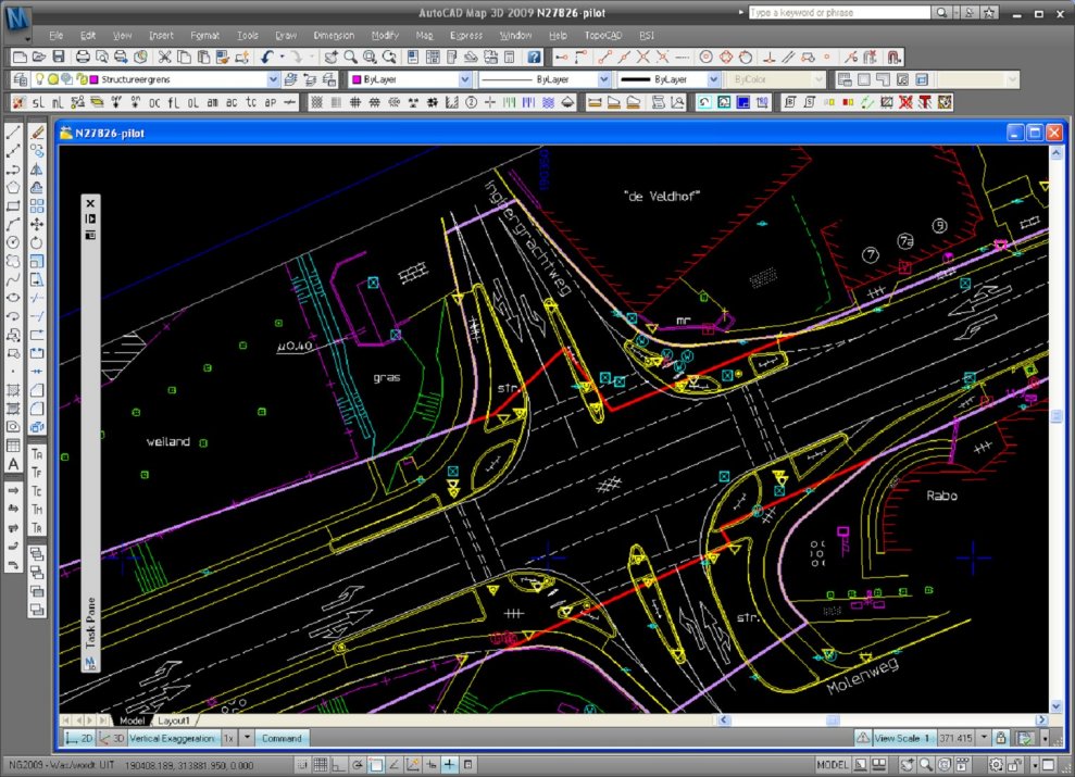
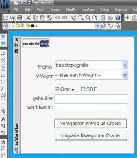
At one of the migration projects where I am involved, the source data is managed in AutoCAD Map and there must be a regular update of the data posted into an Oracle Spatial database. From this Oracle database the large scale data is shared with the GIS-department and used for web-applications. To support this migration process I have developed an AcClassify Workflow utility.

The customer – a Dutch province – has stored their large scale basemaps in DWG-files into a very detailed folder structure on a fileserver. For each provincial road there is a sub-folder, with topografie but also other sub-folders with DWG’s for the theme’s like roadsigns and green management etc.

The Workflow utility – a C# application, that runs inside AutoCAD Map – gives in the UI the possibility to select the roadnumber, the option to delete old data from that roadnumber from Oracle and to upload the new data into Oracle using AcClassify.

If this is an update, than de utility will remove the old data from that roadnumber from their respective feature tables ( for roads, water, buildings etc. ) using SQL Delete statements. Next the utility creates the necessary AcClassify config XML-files ( adding roadnumber, Oracle schema-name etc. ). Than the AcClassify process is started using API-functionality.

With this the workprocess, with a lot of manual action, is reduced to a userfriendly AcClassify Workflow utility.

New : there is an update of this utility that starts the AcClassify process using API-functionality