AutoCAD® Map 3D 2013 – what’s new

AutoCAD® Map 3D GIS and mapping software offers easier access to design, GIS, imagery, point cloud, and business information from a broad range of sources, including ESRI, Bentley, Oracle, GE, and other software providers. By using comprehensive data models for the gas, water, wastewater, and electric industries, you can organize disparate asset information and apply industry standards and business requirements to your data.

Convert GIS and CAD Data to Intelligent Industry Models
With AutoCAD® Map 3D 2013 software, GIS professionals, planners, and civil engineers can more easily create and manage intelligent industry models by converting GIS and CAD data. Users can populate a new industry model from FDO data sources or DWG™ files and map feature classes and attributes. Then, convert the data to a model and save the database as a DWG/DWT file for use in future projects.

AutoCAD Map 3D: Convert GIS and CAD Data to Intelligent Industry Models

Access to Industry Models in More Formats
GIS professionals, planners, and civil engineers can access industry models in Microsoft SQL Server with AutoCAD Map 3D 2013. With the enhanced FDO provider, users can work with enterprise industry models on SQL Server as they do Oracle® systems.

AutoCAD Map 3D: Access to Industry Models in More Formats AutoCAD Map 3D: Checkout Enterprise Industry Model Data

AutoCAD® Map 3D 2012 – what’s new

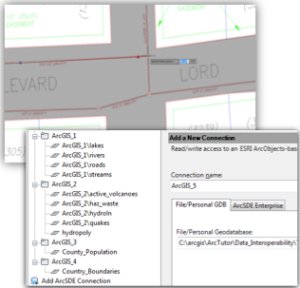
Data Access & Editing
Improved capabilities to access and edit data from more sources enabling you to use your AutoCAD capabilities to edit data.

  • Standalone industry models
  • Consistent AutoCAD editing tools
  • New coordinate systems framework
  • New & enhanced FDO providers

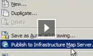
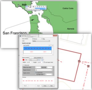
Planning, Analysis & Publishing
New tools for planning, analysis and sharing of information enabling you to better plan for projects.

  • Rich CAD & cartographic display styles & labeling
  • New analytic capabilities for industry models
  • Enhanced DWG™ output
  • Improved grids & graticules

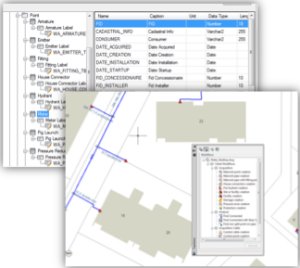
Data Modeling & Management
Powerful tools for the modeling and management of infrastructure information.

  • Extensible vertical industry data models for desktop & enterprise
  • Industry specific workflows & business rules
  • Powerful administration tools
  • Customizable attribute forms, Reports

AutoCAD® Map 3D 2011 – what’s new

AutoCAD® 2011 software
Built on the AutoCAD 2011 Platform. AutoCAD Map 3D 2011 mapping software contains all the features and functionality of AutoCAD® 2011 CAD software, installed automatically.

New Point Cloud Tools
First released as an Autodesk® Subscription Advantage Pack for AutoCAD Map 3D 2010, the new point cloud tools allow for large sets of 3D laser scanning/LIDAR data sets ( often with hundreds of millions of points ) to be imported and visualized within AutoCAD Map 3D software. You can now also stylize point clouds by LAS classification, spatial extents, elevation, or intensity. Point clouds can be used to create DEM surfaces or new 3D features using standard AutoCAD® drafting tools.

Enhanced Workflow Capabilities
Building on functionality introduced in AutoCAD Map 2010 and using Windows® Workflowtm Foundation, AutoCAD Map 3D 2011 makes it even easier to automate repetitive tasks. New Workflow tasks allow you to connect to any vector data source; change and save feature layer styles; and execute AutoCAD®, AutoCAD Map 3D, and AutoCAD® Raster Design commands.

New & Enhanced Data Support
With AutoCAD Map 3D 2011 you can work a wider variety of data. AutoCAD Map 3D 2011 includes support for ESRI® ArcSDE® 9.3.1 (32- and 64-bit), Oracle® 11gR2, Microsoft® SQL Server® 2008 SP1, PostGIS 1.3.6, PostgreSQL 8.3.7-1, and SQLite 3.6.14.

AutoCAD® Map 3D 2010 – what’s new

AutoCAD® 2010 software
AutoCAD Map 3D 2010 software is built on the latest release of AutoCAD platform.

User friendly Ribbon Interface
The new ribbon-style user interface ( UI ) can advance the productivity, because it reduces the number of clicks. This interface presents the different functions in a concise visual format and let you select the desired functions quickly. The ribbon is customizable and can be tailor made for every user.

Improved functionality for importing Survey data
Improved functionality for importing Survey dataAutoCAD Map 3D survey functionality focuses on asset data collection and mapping. This feature allows you to organize, manage, and effectively use data collected in the field within the AutoCAD Map 3D environment. The functionality includes:
– ASCII point and LandXML data import
– Survey datastore and schema
– Point groups
– Creation of FDO features from survey features

New Data Analyse functionality
New Data Analyse functionality
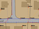
A couple of new overlay functions have been added, that substantially enhances the data analysis functionlity in AutoCAD Map:
– Intersect
– Union
– Erase
– Identity
– Clip
– Paste
– Symmetric difference
Note: these functions work only with FDO-features

New Workflow Framework
New Workflow Framework
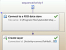
Using the Windows® WorkflowTM Foundation, AutoCAD Map 3D makes it easy to automate repetitive tasks with a new and powerful workflow framework and user interface.
With this framework, you can build, save, and share simple and complex workflows with a visual editor. Workflows can include logic and initiate calls to other workflows—all with a single mouse click, improving efficiency and consistency in results.

New FDO-providers

New FDO-providersAutoCAD Map 3D 2010 supports now Microsoft SQL Server 2008 with the new Spatial functionality.
And there is an Autodesk FDO-Provider for GE Smallworld available in the Subscription Center for users with an Autodesk® Subscription contract.