
AutoCAD Map/FDO <=> ESRI ArcSDE
Before AutoCAD Map can make an FDO-connection into ESRI ArcSDE server, there have to be 3 so called DLL’s ( pe.dll, sde.dll and sg.dll ) copied into the “AutoCAD Map software”/FDO/bin-folder.
Using “Map Display Manager => Data => Connect to Data” to add an ArcSDE connection in the Data Connect UI. In this connection screen the server name and instance needs to be entered and after that the username/password of a registered ArcSDE-user.
Map will research, with the ArcSDE-credentials of that user, which feature-tables are available and analyse those tables to determine the correct structure. Note: if the ArcSDE-user has full access to the database, than this analyse will take longer – take care that the user has restricted credentials only for the desired tables for a better performance.
After this analyse the list with available features will be displayed and the user can select one or mutiple tables to connect to the Map-session. Next the data is displayed, with the option to filter on location and/or attributes.
AutoCAD Map/FDO <=> Oracle Spatial
Before AutoCAD Map can make an FDO-connecton into an Oracle 9i or 10g Spatial server, there have to be an Oracle 10g Client ( or an Instant Client ) installed on the Map-machine. Besides that Map needs Oracle Workspace Manager to be installed on the Oracle server – this is used for Long Transactions and Versioning.
Using “Map Display Manager => Data => Connect to Data” to add an Oracle connection in the Data Connect UI. In this connection screen the service name needs to be entered and after that the username/password of a registered Oracle-user.
Map will search by default for FDO-schema’s ( tables with FDO-metadata ) and display these in the DataStore overview. Map can analyse also schema’s without FDO-metadata en determine the structure ( comparable with the description above for ArcSDE ).
After this the list with available features will be displayed and the user can select one or mutiple tables to connect to the Map-session. Next the data is displayed, with the option to filter on location and/or attributes.
see also: Direct access to Spatial Data using FDO-technology
 ArcGIS for AutoCAD is a free of charge downloadable plugin from ESRI, currently available for AutoCAD 2007, 2008 and 2009.

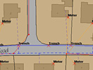 AutoCAD Map 3D survey functionality focuses on asset data collection and mapping. This feature allows you to organize, manage, and effectively use data collected in the field within the AutoCAD Map 3D environment. The functionality includes:
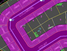 A couple of new overlay functions have been added, that substantially enhances the data analysis functionlity in AutoCAD Map:
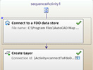 Using the Windows® WorkflowTM Foundation, AutoCAD Map 3D makes it easy to automate repetitive tasks with a new and powerful workflow framework and user interface.
 AutoCAD Map 3D 2010 supports now Microsoft SQL Server 2008 with the new Spatial functionality.