
AutoCAD® 2011 software
Built on the AutoCAD 2011 Platform. AutoCAD Map 3D 2011 mapping software contains all the features and functionality of AutoCAD® 2011 CAD software, installed automatically.
New Point Cloud Tools
 First released as an Autodesk® Subscription Advantage Pack for AutoCAD Map 3D 2010, the new point cloud tools allow for large sets of 3D laser scanning/LIDAR data sets ( often with hundreds of millions of points ) to be imported and visualized within AutoCAD Map 3D software. You can now also stylize point clouds by LAS classification, spatial extents, elevation, or intensity. Point clouds can be used to create DEM surfaces or new 3D features using standard AutoCAD® drafting tools.
Enhanced Workflow Capabilities
 Building on functionality introduced in AutoCAD Map 2010 and using Windows® Workflowtm Foundation, AutoCAD Map 3D 2011 makes it even easier to automate repetitive tasks. New Workflow tasks allow you to connect to any vector data source; change and save feature layer styles; and execute AutoCAD®, AutoCAD Map 3D, and AutoCAD® Raster Design commands.
New & Enhanced Data Support
 With AutoCAD Map 3D 2011 you can work a wider variety of data. AutoCAD Map 3D 2011 includes support for ESRI® ArcSDE® 9.3.1 (32- and 64-bit), Oracle® 11gR2, Microsoft® SQL Server® 2008 SP1, PostGIS 1.3.6, PostgreSQL 8.3.7-1, and SQLite 3.6.14.

 AutoCAD Map 3D survey functionality focuses on asset data collection and mapping. This feature allows you to organize, manage, and effectively use data collected in the field within the AutoCAD Map 3D environment. The functionality includes:
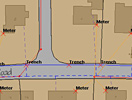
 A couple of new overlay functions have been added, that substantially enhances the data analysis functionlity in AutoCAD Map:
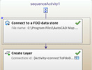 Using the Windows® WorkflowTM Foundation, AutoCAD Map 3D makes it easy to automate repetitive tasks with a new and powerful workflow framework and user interface.
 AutoCAD Map 3D 2010 supports now Microsoft SQL Server 2008 with the new Spatial functionality.