YuZu is a smart software application that captures existing conditions into the AutoCAD and Revit environment. It draws while you measure, connecting your handheld laser instrument with Bluetooth connection on site to your tablet or laptop-pc.
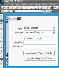
At one of the migration projects where I am involved, the source data is managed in AutoCAD Map and there must be a regular update of the data posted into an Oracle Spatial database. From this Oracle database the large scale data is shared with the GIS-department and used for web-applications. To support this migration process I have developed an AcClassify Workflow utility.
The customer – a Dutch province – has stored their large scale basemaps in DWG-files into a very detailed folder structure on a fileserver. For each provincial road there is a sub-folder, with topografie but also other sub-folders with DWG’s for the theme’s like roadsigns and green management etc.
The Workflow utility – a C# application, that runs inside AutoCAD Map – gives in the UI the possibility to select the roadnumber, the option to delete old data from that roadnumber from Oracle and to upload the new data into Oracle using AcClassify.
If this is an update, than de utility will remove the old data from that roadnumber from their respective feature tables ( for roads, water, buildings etc. ) using SQL Delete statements. Next the utility creates the necessary AcClassify config XML-files ( adding roadnumber, Oracle schema-name etc. ). Than the AcClassify process is started using API-functionality.
With this the workprocess, with a lot of manual action, is reduced to a userfriendly AcClassify Workflow utility.
New : there is an update of this utility that starts the AcClassify process using API-functionality
In my previous post I was talking about a CSWclient prototype. During the Autodesk EMEA GeoSpatial TechCamp2008 in Disneyland Paris, I’ve presented an SDI workflow demo on mainstage.
A city is planning a new housing area and has to extend the existing water, gas and electricity networks.
On the existing basemap they have planned the new houses and streets, and from the utility company they would like to add the existing infrastructure to connect the new utility design.
With the CSWclient they ask the SDI from the utility company about available maps in the area ‘Kouwenhovenselaan’.
The response from the SDI – a list with references to available maps – is used to connect the maps to the AutoCAD Map work-session.
The trenches for the new utilities go to the contractor, who returns an as-built drawing with the exact location after the construction has finished.
On this kind of CAD-drawings the contractor is using texts to mark the used materials and diameters.
It is important to migrate not only the location information, but also materials and diameters into the utility maintenance database.
With a special function in AcClassify it is possible to find texts on a certain layer within a buffer around the lines.
These text values are written as diameter attributes into the database.
AcClassify – an AutoCAD Map utility from Autodesk Consulting – developed to leverage expertise around the AutoCAD Map drawing-structure saving this into migration-profiles.
Working with AcClassify distinguish the following fases:
Classification-fase
Herewith we define features, how are they represented in the drawing and which specific requirements should they have to become such a feature.
for example the feature “building” consist of lineair objects with the layernamen = “B??_?”
Mapping-fase
Herewith we connect the CAD-properties ( the input ) with the feature-properties in the database ( the output ), optionally “translating” for example colors into diameters.
AcClassify can create the schema-definition of the feature-tables in this fase, or an existing database-schema can be imported.
Migration-fase
In this fase the current drawing will be migrated into the database.
There is also a command to migrate a complete folder of equal drawings with the same migration-profile.
CAD-data is in general structured according to a layer-model, where color, linetypes and blocknames can be used to make more difference.
GIS-data is in general structured according to a feature-model, where objects from the same kind resides in the same feature-table provided with their specific attributes.
AcClassify – an AutoCAD Map utility from Autodesk Consulting – can filter CAD-data, based on various CAD-properties. AcClassify can “recognize” for example pipes of a certain type. After that AcClassify can migrate those CAD-entities into their corresponding GIS-features and optionally “tanslate” for example color-codes into diameters or linetypes into materials.
The major challenge encountered during this process is due to the lack of rigid attribute association with an AutoCAD DWG. AcClassify is designed to collect expertise around these DWG-entities to create a migration-schema which “maps” the unbound attributes to columns in a table, such as found in GIS database-tables.
AcClassify is a modular migration tool which is designed to work on a variety of input sources and output targets. It archives this by de-coupling the input and output phases from the classification engine with modules called adapters, configured in XML-config files.

 At one of the migration projects where I am involved, the source data is managed in AutoCAD Map and there must be a regular update of the data posted into an Oracle Spatial database. From this Oracle database the large scale data is shared with the GIS-department and used for web-applications. To support this migration process I have developed an AcClassify Workflow utility.
 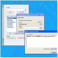 AcClassify – an AutoCAD Map utility from Autodesk Consulting – developed to leverage expertise around the AutoCAD Map drawing-structure saving this into migration-profiles.
 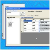 Mapping-fase
 AcClassify – an AutoCAD Map utility from Autodesk Consulting – can filter CAD-data, based on various CAD-properties. AcClassify can “recognize” for example pipes of a certain type. After that AcClassify can migrate those CAD-entities into their corresponding GIS-features and optionally “tanslate” for example color-codes into diameters or linetypes into materials.