AutoCAD® Map 3D 2013 – what’s new

AutoCAD® Map 3D GIS and mapping software offers easier access to design, GIS, imagery, point cloud, and business information from a broad range of sources, including ESRI, Bentley, Oracle, GE, and other software providers. By using comprehensive data models for the gas, water, wastewater, and electric industries, you can organize disparate asset information and apply industry standards and business requirements to your data.

Convert GIS and CAD Data to Intelligent Industry Models
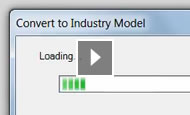
With AutoCAD® Map 3D 2013 software, GIS professionals, planners, and civil engineers can more easily create and manage intelligent industry models by converting GIS and CAD data. Users can populate a new industry model from FDO data sources or DWG™ files and map feature classes and attributes. Then, convert the data to a model and save the database as a DWG/DWT file for use in future projects.

AutoCAD Map 3D: Convert GIS and CAD Data to Intelligent Industry Models

Access to Industry Models in More Formats
GIS professionals, planners, and civil engineers can access industry models in Microsoft SQL Server with AutoCAD Map 3D 2013. With the enhanced FDO provider, users can work with enterprise industry models on SQL Server as they do Oracle® systems.

AutoCAD Map 3D: Access to Industry Models in More Formats AutoCAD Map 3D: Checkout Enterprise Industry Model Data

AutoCAD® Map 3D 2011 – what’s new

AutoCAD® 2011 software
Built on the AutoCAD 2011 Platform. AutoCAD Map 3D 2011 mapping software contains all the features and functionality of AutoCAD® 2011 CAD software, installed automatically.

New Point Cloud Tools
First released as an Autodesk® Subscription Advantage Pack for AutoCAD Map 3D 2010, the new point cloud tools allow for large sets of 3D laser scanning/LIDAR data sets ( often with hundreds of millions of points ) to be imported and visualized within AutoCAD Map 3D software. You can now also stylize point clouds by LAS classification, spatial extents, elevation, or intensity. Point clouds can be used to create DEM surfaces or new 3D features using standard AutoCAD® drafting tools.

Enhanced Workflow Capabilities
Building on functionality introduced in AutoCAD Map 2010 and using Windows® Workflowtm Foundation, AutoCAD Map 3D 2011 makes it even easier to automate repetitive tasks. New Workflow tasks allow you to connect to any vector data source; change and save feature layer styles; and execute AutoCAD®, AutoCAD Map 3D, and AutoCAD® Raster Design commands.

New & Enhanced Data Support
With AutoCAD Map 3D 2011 you can work a wider variety of data. AutoCAD Map 3D 2011 includes support for ESRI® ArcSDE® 9.3.1 (32- and 64-bit), Oracle® 11gR2, Microsoft® SQL Server® 2008 SP1, PostGIS 1.3.6, PostgreSQL 8.3.7-1, and SQLite 3.6.14.

AcClassify Workflow utility ( update )

AcClassify Workflow utility
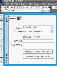
At one of the migration projects where I am involved, the source data is managed in AutoCAD Map and there must be a regular update of the data posted into an Oracle Spatial database. From this Oracle database the large scale data is shared with the GIS-department and used for web-applications. To support this migration process I have developed an AcClassify Workflow utility.

The customer – a Dutch province – has stored their large scale basemaps in DWG-files into a very detailed folder structure on a fileserver. For each provincial road there is a sub-folder, with topografie but also other sub-folders with DWG’s for the theme’s like roadsigns and green management etc.

The Workflow utility – a C# application, that runs inside AutoCAD Map – gives in the UI the possibility to select the roadnumber, the option to delete old data from that roadnumber from Oracle and to upload the new data into Oracle using AcClassify.

If this is an update, than de utility will remove the old data from that roadnumber from their respective feature tables ( for roads, water, buildings etc. ) using SQL Delete statements. Next the utility creates the necessary AcClassify config XML-files ( adding roadnumber, Oracle schema-name etc. ). Than the AcClassify process is started using API-functionality.

With this the workprocess, with a lot of manual action, is reduced to a userfriendly AcClassify Workflow utility.

New : there is an update of this utility that starts the AcClassify process using API-functionality