
 At one of the migration projects where I am involved, the source data is managed in AutoCAD Map and there must be a regular update of the data posted into an Oracle Spatial database. From this Oracle database the large scale data is shared with the GIS-department and used for web-applications. To support this migration process I have developed an AcClassify Workflow utility.
The customer – a Dutch province – has stored their large scale basemaps in DWG-files into a very detailed folder structure on a fileserver. For each provincial road there is a sub-folder, with topografie but also other sub-folders with DWG’s for the theme’s like roadsigns and green management etc.
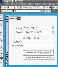
The Workflow utility – a C# application, that runs inside AutoCAD Map – gives in the UI the possibility to select the roadnumber, the option to delete old data from that roadnumber from Oracle and to upload the new data into Oracle using AcClassify.
If this is an update, than de utility will remove the old data from that roadnumber from their respective feature tables ( for roads, water, buildings etc. ) using SQL Delete statements. Next the utility creates the necessary AcClassify config XML-files ( adding roadnumber, Oracle schema-name etc. ). Than the AcClassify process is started using API-functionality.
With this the workprocess, with a lot of manual action, is reduced to a userfriendly AcClassify Workflow utility.
New : there is an update of this utility that starts the AcClassify process using API-functionality
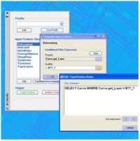 AcClassify – an AutoCAD Map utility from Autodesk Consulting – developed to leverage expertise around the AutoCAD Map drawing-structure saving this into migration-profiles.
 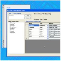 Mapping-fase
 AcClassify – an AutoCAD Map utility from Autodesk Consulting – can filter CAD-data, based on various CAD-properties. AcClassify can “recognize” for example pipes of a certain type. After that AcClassify can migrate those CAD-entities into their corresponding GIS-features and optionally “tanslate” for example color-codes into diameters or linetypes into materials.