
Oasen drinkwater, a water company manages its pipeline network in DiaGIS, a GIS management system developed by SPIE Technology. In addition to managing the existing network, they make drawings for maintenance or enhancements to the network. The physical work on the network is performed by contractors.
These contractors are obliged to survey the new pipelines and to create an asbuild AutoCAD drawing for the water company. Currently, only the locations of the pipes are returned, not the attribute information such as material, diameter, etc. When processing these revision drawings into the GIS management system, often questions from the engineer to the contractor emerge and it takes relatively much time before the network is up-to-date in the GIS management system.
 Oasen drinkwater wants to optimize this process and SPIE Technology came to vdPConsulting requesting the development of an AutoCAD plugin; drawingAssistant.
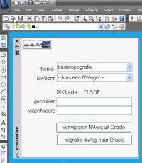
When the plugin is loaded into AutoCAD at first an XML configuration file is processed. This file is created by DiaGIS and contains all objects and their attributes necessary for the contractor to create the asbuild drawings. Then the plugin dynamically creates the user interface form that adapts itself when another object is selected from the list of possible objects. When the corresponding attributes are provided with the correct values, the object can be drawn. The plugin also checks first if all mandatory attributes are filled in.
Often measurements are captured by surveying instruments and the pipes are drawn as “ordinary” AutoCAD polylines in the drawing. The drawingAssistant plugin has, besides the drawing functions, also functionality to classify such a polyline as pipe including the desired attributes.
To exchange data with the GIS management system, the plugin has an export function to GML. DiaGIS has a GML import function which handles the revisions directly. Of course, the engineer has to check the result afterwards, but delivery of the revisions is simplified and the GIS management system is faster up-to-date.
If you want more information about the drawingAssistant plugin, please contact me.
 At one of the migration projects where I am involved, the source data is managed in AutoCAD Map and there must be a regular update of the data posted into an Oracle Spatial database. From this Oracle database the large scale data is shared with the GIS-department and used for web-applications. To support this migration process I have developed an AcClassify Workflow utility.
 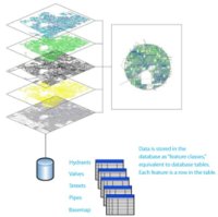 In contrast with previous versions of AutoCAD Map, geometies are no longer imported from SDF, Shape-files or Oracle-tables. We work directly on the files and databasetables in their own native format, without translation by import/export. Multiple users can connect to the same data at the same time, that is a big advantage and solves problems due to copies and different versions floating around.
 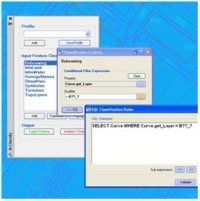 AcClassify – an AutoCAD Map utility from Autodesk Consulting – developed to leverage expertise around the AutoCAD Map drawing-structure saving this into migration-profiles.
 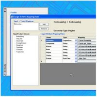 Mapping-fase