
AutoCAD uses different light types to illuminate a rendered scene.
One of these light types is called a distant light.
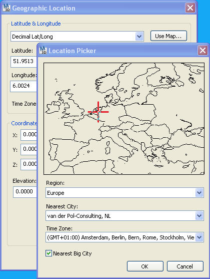
When you add a distant light, you can use the Sun Angle Calculator, which includes an option for Geographic Location.
In the Geographic Location dialog box, you can pick a location from a map, or select a city from a list.
The selected point provides the information AutoCAD needs to calculate the sun angle for the distant light at a given date & time.
This information is also use for Georeferencing the DWG.
You can easily add your own location to the pre-defined list of cities.
The list of cities is stored in a file called: SITENAME.TXT
Located in: C:Documents and SettingsusernameApplication DataAutodeskAutoCAD Map 3D 2009R17.2enuSupport
Open the file SITENAME.TXT in a text editor.
Add your locatie in latitude and longitude coordinates, for example: +51.9513 +006.0024 +van der Pol-Consulting, NL
Save the file.
Make sure to restart AutoCAD, before this addition takes effect.
command reference:
GEOGRAPHICLOCATION – specifies the latitude and longitude of a location, stored in the Geo-Marker.
GEOMARKERVISIBILITY – controls whether the Geo-Marker is displayed ( 0 = not visible, 1 = visible ).
GEOLATLONGFORMAT – controls the format of the latitude or longitude values in the Geographic Location dialog box, and the coordinate status bar in Geographic mode ( 0 = in decimal degrees, 1 = in degrees minutes seconds ).
 BootCamp is a Mac OS X 10.5 component, which allows you to install Windows XP or Vista on a seperate partition to run Windows apps. Those apps can make use of the Mac hardware processors, 3D graphics accelerators etc.