
![]() Autodesk Consulting France is working on a project for the Assemblée Nationale to migrate 164 facility management drawings into an Oracle database. vdPConsulting is involved in the project as sub-contractor because of their extended knowledge of AcClassify.
Autodesk Consulting France is working on a project for the Assemblée Nationale to migrate 164 facility management drawings into an Oracle database. vdPConsulting is involved in the project as sub-contractor because of their extended knowledge of AcClassify.
These drawings are interior maps of buildings, where the offices, meeting rooms, hallways, restrooms, etc. are displayed as closed polylines on a certain layer. Within such a space a block is drawn, in which attributes like for example roomnumbers are stored.
AcClassify identifies these areas and finds the containing blocks & attributes, then these areas are written to the database as polygon objects. The information from the attributes are stored as properties of these polygons. In addition, all other lines, blocks and texts are stored as lines and points to be used as background information in the new drawings. These new drawings will be displayed in a web viewer.
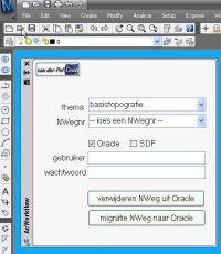 At one of the migration projects where I am involved, the source data is managed in AutoCAD Map and there must be a regular update of the data posted into an Oracle Spatial database. From this Oracle database the large scale data is shared with the GIS-department and used for web-applications. To support this migration process I have developed an AcClassify Workflow utility.
 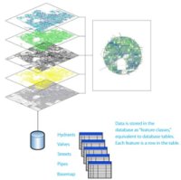 In contrast with previous versions of AutoCAD Map, geometies are no longer imported from SDF, Shape-files or Oracle-tables. We work directly on the files and databasetables in their own native format, without translation by import/export. Multiple users can connect to the same data at the same time, that is a big advantage and solves problems due to copies and different versions floating around.
 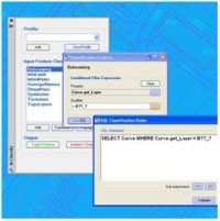 AcClassify – an AutoCAD Map utility from Autodesk Consulting – developed to leverage expertise around the AutoCAD Map drawing-structure saving this into migration-profiles.
 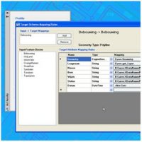 Mapping-fase
 AcClassify – an AutoCAD Map utility from Autodesk Consulting – can filter CAD-data, based on various CAD-properties. AcClassify can “recognize” for example pipes of a certain type. After that AcClassify can migrate those CAD-entities into their corresponding GIS-features and optionally “tanslate” for example color-codes into diameters or linetypes into materials.